Greenfield International Airport: Difference between revisions
Jump to navigation
Jump to search
No edit summary |
No edit summary |
||
| Line 9: | Line 9: | ||
| ICAO = KGIA | | ICAO = KGIA | ||
| type = Public | | type = Public | ||
| city-served = Greenfield Metropolitan | | city-served = Greenfield Metropolitan Area | ||
| location = [[Lannex]], Greenfield, U.S. | | location = [[Lannex]], Greenfield, U.S. | ||
| opened = 0.5.4 | | opened = 0.5.4 | ||
Revision as of 19:11, 24 February 2022
Greenfield International Airport | |||||||||||||||||||
|---|---|---|---|---|---|---|---|---|---|---|---|---|---|---|---|---|---|---|---|
| <<GIA Airport Logo>> | |||||||||||||||||||
| <<GIA Aerial Shot (Render?)>> Aerial shot of Greenfield International Airport | |||||||||||||||||||
| |||||||||||||||||||
| Summary | |||||||||||||||||||
| Airport type | Public | ||||||||||||||||||
| Serves | Greenfield Metropolitan Area | ||||||||||||||||||
| Location | Lannex, Greenfield, U.S. | ||||||||||||||||||
| Opened | 0.5.4 | ||||||||||||||||||
| Hub for | |||||||||||||||||||
| Focus city for | |||||||||||||||||||
| Elevation | 31 ft / 9 m | ||||||||||||||||||
| Coordinates | 3600, -1900 | ||||||||||||||||||
| Map | |||||||||||||||||||
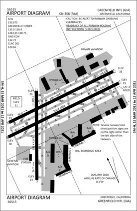
 GIA Airport Diagram | |||||||||||||||||||
| Runways | |||||||||||||||||||
| |||||||||||||||||||