North Lannex: Difference between revisions
No edit summary |
(→Transit: Added highway information.) Tags: Mobile edit Mobile web edit |
||
| (One intermediate revision by one other user not shown) | |||
| Line 7: | Line 7: | ||
* [[Thorne Botanical Garden]] | * [[Thorne Botanical Garden]] | ||
* Wynne Chavez Ecological Reserve | * Wynne Chavez Ecological Reserve | ||
*[[wikipedia:E-ZPass|EZ-Pass]] [[wikipedia:Toll_road|Toll Station]] and [[wikipedia:California_Highway_Patrol|California Highway Patrol]] outpost | |||
* [[Greenfield Bay Bridge]] | * [[Greenfield Bay Bridge]] | ||
| Line 15: | Line 16: | ||
[[Highway]] | [[Highway]] | ||
- | - [[I-205]] runs to the west of the district, and three exits serve the area. | ||
== Gallery == | == Gallery == | ||
Latest revision as of 09:03, 10 May 2023
| North Lannex | |
|---|---|
 | |
| Status | Incomplete |
| Type | District |
| Location | 5030, -3250 |
| Introduced | 0.5.4 |
| Built by | -- |
| Elevation | 16ft (5m) |
| Website | www.lannex.gov/north-expansion-project |
North Lannex is a designated community area in the northeast area of Greenfield, CA. It is located northeast of Downtown Greenfield along I-205 and is adjacent to Greenfield International Airport. North Lannex currently lies as a developing low-density commercial neighborhood, driving businesses further from the city possibly as a result of gentrification from nearby Lannex and Rio Pueblo. Due to the rural area, crime statistics and gang activity are higher than neighboring communities with many Lannex leaders considering the area as an impoverished area requiring too much tax money that the community cannot provide.
Notable builds
- Thorne Botanical Garden
- Wynne Chavez Ecological Reserve
- EZ-Pass Toll Station and California Highway Patrol outpost
- Greenfield Bay Bridge
Transit
North Lannex is situated along the I-205 highway, allowing commuters to easily navigate the small district with easy street access.
- I-205 runs to the west of the district, and three exits serve the area.
Gallery
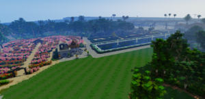
Thorne Botanical Garden
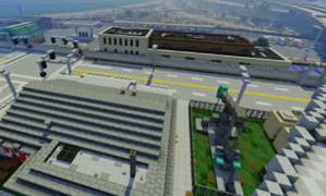
Main strip of businesses
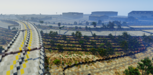
North view of airport


