History of Greenfield: Difference between revisions
m (→Postwar Era) |
mNo edit summary |
||
| Line 13: | Line 13: | ||
== Post-conquest Era == | == Post-conquest Era == | ||
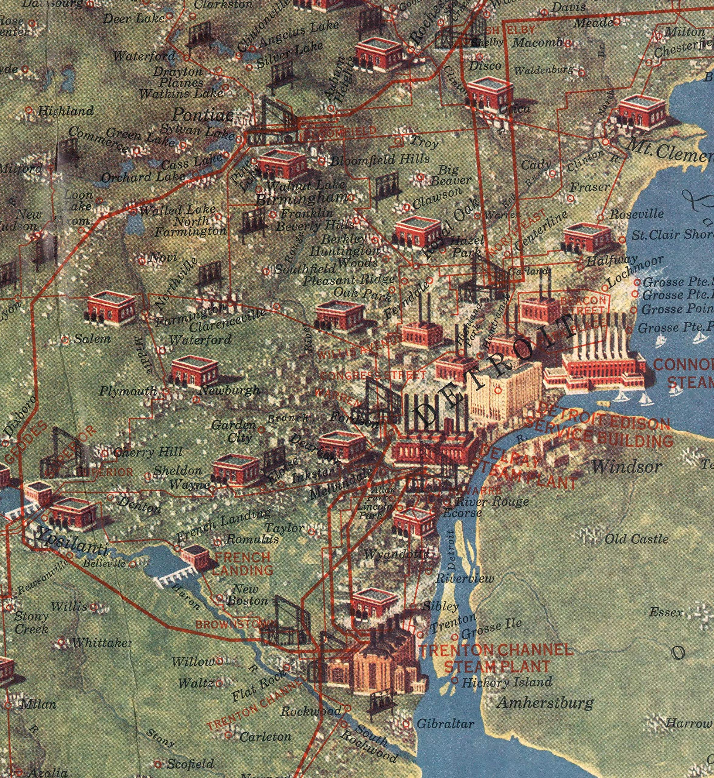
[[File:GF1850.png|alt=old greenfield map|thumb|190x190px|Topographic map of Greenfield showing Streets, Plots, Landowners, Buildings, and Height Contours. (Yuri Dopted, ca 1850)]] | (Pictorial Map like https://m.media-amazon.com/images/I/A1X0fElieSL.jpg showing various greenfield buildings of 1920s, plus Lompoc, Santa Barbara, and other cities)[[File:GF1850.png|alt=old greenfield map|thumb|190x190px|Topographic map of Greenfield showing Streets, Plots, Landowners, Buildings, and Height Contours. (Yuri Dopted, ca 1850)]] | ||
== World War 2 == | == World War 2 == | ||
Latest revision as of 17:44, 26 October 2025
Indigenous History
The Region which is now home to Greenfield was first settled by the Chumash and Ineseño Peoples for thousands of years prior to Spanish Colonization. many tribal villages were set up and approximately 20,000 people lived in the area. The biggest settlement, home to around 300 Chumash people was named puqaqa' t'ot, meaning "place of resting waters".
Spanish Era

Maritime explorer Juan Rodríguez Cabrillo would first Visit the Greenfield Area on October 18th, 1542, he claimed the Upper and Lower bays for the Spanish Empire.
Later in 1790 Spanish missionary Juan De Franklin together with a group of 72 Settlers, who would name the area Punto de Cazadores (Hunter’s Point) due to the cool climate and large amount of animals
Mexican Era
Starting in 1846, Mexico and the United States waged a war. American conquest of Greenfield happened quickly with no revolt from the Californios breaking out in Greenfield contrary to Los Angeles and San Diego. The Treaty of Guadalupe Hidalgo would solidify the American Conquest in 1848 of Greenfield and what would eventually become the Southwestern United States
Post-conquest Era
(Pictorial Map like https://m.media-amazon.com/images/I/A1X0fElieSL.jpg showing various greenfield buildings of 1920s, plus Lompoc, Santa Barbara, and other cities)

World War 2
1940s - headed by Lemon
During World War II, Greenfield would see an increase in relevance. Greenfield Port’s importance would increase due to government Subsidies for shipbuilding resulting in a decline of nearby Delrey. The city would sprawl westward due to the needed jobs and many factories would open up. Meanwhile, the Booming village of Rockwell would see combat similar to the attack on Ellwood in Santa Barbara when on February 27th 1942 the Japanese Submarine I-17 would attack the Rockwell Refinery resulting in minor damages to the building, ending up in it being torn down after the war in 1946.
After the attack on Rockwell, a fake town would be constructed to hide a warehouse in anticipation of an attack on Greenfield Municipal Airport which would see use as a training ground and production location for Douglas C-54 aircraft. Eventually the airport would be designated as an International Airport and construction of a second Terminal started which would be finished in 1955.
[Ongoing. Defer to Lemon for any suggestions to this section.]
Postwar Era
1950s - 1970s (La Limon)
After World War II ended, Greenfield would see a boom in population and the annexation of Rockwell. With work starting on the Interstate system Greenfield would end up having 472,932 in 1950, around two and a half times as much compared to its population of only 183,293 in 1930. This rapid population growth sprawled the city into nearby communities such as Los Llanos. Meanwhile factories in Baron's Bar shifted more towards construction to complement this expansion.
ashfield joins greenfield in 50s and get massive funding or some shit herew
[Ongoing. Defer to Lemon for any suggestions to this section.]
The Crime Wave of 1980 to 1987 - headed by Caelum
During the 1980s, Greenfield experienced a surge in crime brought about by the drug trade coming in from Central America and rampant corruption in the Greenfield Police Department and the Greenfield Port Authority. Police were paid off by both the wealthy to keep their homes and businesses safe and criminal entities to protect their rackets and illegal activities. During this decade, Greenfield also became the largest point of entry for illegal immigrants in California. As the city was ravaged by wave upon wave of crime, the city's economy nearly collapsed as businesses and citizens fled to other parts of California.
In 1984, Emilio DeSantis was elected as Mayor in a landslide win, ousting Jeremy Loughton after a brutal campaign in which both parties unabashedly sought to discredit each other. Mayor DeSantis' policies on reform and recovery were credited for pulling Greenfield from the brink of economic collapse. He is best known for firing nearly 90% of the city's entire police force and government officials.
[Ongoing. Defer to Caelum for any suggestions to this section.]
1990s - headed by Golden
After the police reforms of the 1980s the crime and drug epidemic came to a halt and the economy of the city became healthier. Mayor Emilo Desantis called for expansions to the Greenfield budget to provide for beter connectivity in public transport, more jobs and better tourism. The city added 3000 new employees to the city, primarily due to the redevelopment of the North Of Market and Little Kyoto districts. But also the recently constructed Delrey Boardwalk. The Green line would start construction in 1991 and the Blue line in 1993. They were planned to reach previously unconnected areas like Sonora and Rockwell. And also to western districts like Barons Bar and Westwood to promote growth
During the 90s the demographic of the city shifted. The port of Greenfield would expand, International trade would lead to hundreds of thousands of jobs in the Greenfield metropolitan area. Aerospace and vehicle industry would shut down, and industrial areas like Barons Bar were in a steady decline. Desire for residential housing in the downtown area would lead to gentrification. Historical commercial buildings would be renovated into condos, and construction of highrise apartments & condominiums were started.
The 1994 Greenfield Earthquake - headed by Golden
(full article - The 1994 Greenfield Earthquake)
On July 14th, 1994 an earthquake measuring 7.5 on the moment magnitude scale struck the Santa Ynez fault near Ashfield. The quake severely damaged many of the city's freeways, most notably the I-405 bridge collapse between downtown Greenfield and Ashfield. It also severely altered the skyline, with the collapse of the 30 story Bank Of Despair Tower. The earthquake killed 203 people and caused $42 billion in damage, making it the costliest earthquake in american history. The destructive earthquake would halt many ongoing projects and made the city go into a short decline up untill the early 2000s.
21st Century
2000s - headed by Golden
After the earthquake, the decline and disinvestment into the city continued untill 2002 when a new mayor, Bruce Holloway was elected. He promised for growth and the revitalization of districts near downtown Greenfield.
Both the green and blue LRT lines finished construction and opened in 2003. With this came the first talks about a new high end waterfront neighbourhood in baronsbar, and new housing on the former parking lots of the Nazoma Monolith. With this, multiple districts around the city, like Del Rey, Peralta Beach, South Hill and North of Market were rezoned to incentivise new housing construction
Bruce Holloway kept his promise of new growth and the city saw numerous new highrises built around the financial district. The Downtown waterfront plan was also made. In this plan many of the piers would be converted into other uses, such as the Greenfield Aquarium, which would open in 2006
Unfortunately the Great Recession would halt this growth. It would indefinitely halt many construction projects around the city, such as the redevelopment of Baron's Bar, Peralta Beach and the waterfront redevelopment plan.
[Ongoing. Defer to Golden for any suggestions to this section.]
2010s - headed by Moon moon, Golden
In the early 2010s, the city began to see major economic recovery after the recession back in 2008. Mayor Bruce Holloway spent tons of money strengthening the infrastructure, and improving the tourist appeal by continuing the waterfront redevelopment plan. Another plan was made to redevelop the Ashfield waterfront to connect the Delrey neighbourhood with the rest of Ashfield.
During the 2010s the city would grow immensely etc
[Ongoing. Defer to Moon Moon or Golden for any suggestions to this section.]
---Original History---
The Greenfield region was originally settled by the Chumash people. Many small settlements over the years were located in this area, however most of the tribe's people preferred to stay farther inland because of the frequent flooding caused by the largely flat delta. Maritime explorers from the Spanish empire claimed all of southern California for the Spanish Empire in 1542 and would reach the site of Greenfield in 1773 and note its possible future of a trading port, however because of the shallow delta no further exploration of the area was done.
Greenfield was founded originally as Hunters Point in 1790, by an Irish explorer 'Sean O'Riley'. Sean was the very first Irish explorer to reach the west coast of America amongst the other settlers in the area who were mostly of Spanish descent. The settlement was named 'Hunters Point' due to its heavy animal population, and it's cooler temperature which was great for hunting. With lots of food in the area and fertile land, the settlement quickly attracted settlers from many parts of the west coast. Unlike the cities of Los Angeles to the south and San Francisco to the north, Hunters Point grew slower.
During this period the entire So-Cal area dubbed New Spain became independent from the Spanish empire in 1821, and the small hunting town now existed within the Mexican Republic. Because of the settlement's small size at the time, it was not considered a key target for either the Mexicans or the US Army during the Mexican-American War. There was still a small fort built by the US on the west coast of the Hunters river that was named Fort Franklin but it never saw any fighting.
By this time Hunters point was growing and hunting was no longer a sustainable industry for the village as most of the animals were hunted to almost complete region extinction. Because of this the village began looking towards other options to stay alive, and realized that its inland bay could be a great shipping port if the delta was dredged enough for shipping. So along with help from the US Army corps of engineers a lengthy dredging project was begun. One of the key individuals pushing for the dredging was a local landowner named Jerimiah Kennedy. He had become mildly wealthy for being a successful land speculator in the region. He saw the immense benefit of the muddy flooded land near the delta and bought it for cheap from the village. Jeremiah then used his influence to make sure the dredged dirt from the delta was dumped in his previously unusable land, making it the most valuable land in the village. He then began subdividing his land along the water and selling it to local industry and shipping companies. His immense success and a feeling of being cheated out of profits caused the village of Hunterspoint to impose heavy taxes on the new area. However Jerimiah was able to use a legal loophole from the sale of the land to claim the land was not part of the incorporated land of Hunterspoint, and in an equally petty move petitioned the governor to make a new town. Jeremiah named his town Greenfield in order to hopefully encourage pilgrims from the east to settle down there.
Because of this, Greenfield became a small boom town while Hunterspoint stalled in growth. During this time both towns began claiming land for their region leading to multiple disputes, and even at one point, a small skirmish along the border of the two towns that led to two dead and 4 injured. Because of this, the governor sent the US army to take control. Over the watchful eye of uncle Sam, both villages, now full fledged cities signed a land agreement. This agreement called the Hunterspoint-Greenfield Land Agreement, stated that the city of Greenfield would have rights to the land east of the Hunters river, and Hunterspoint would keep its historic city core on the east side, but get land rights to the west of the river. This deal was only made possible because of a new toll bridge the state of California agreed to fund. The Hunters bridge crossed the river for the first time, and also was tall enough to allow current freighters through. The city of Hunterspoint, not wanting to miss out on an opportunity, heavily marketed the new land to the west as prime industrial land for the current industrial revolution spreading across the country.
Because of the huge boom of industry in Hunterspoint, a major need for housing became apparent. The relative filth of Hunters Point at the time meant that the majority of the working class looked across the river to Greenfield for housing, and land speculators were happy to sell. Because of this, Hunterspoint became the de facto working city while Greenfield became the cultural hub and living quarters for a majority of the region. During this time, the population of Greenfield doubled that of Hunterspoint with approximately 100,000 residents.
During this time the railroad made it to both cities, and a huge fight arose on to whether the station, which was located in Hunterspoint due to all the industry, should be labeled as Hunterspoint or the much more populous city of Greenfield. There were several cases of city officials sneaking out at night to remove the signage and replace it with their own. This lead to the city placing armed guards around the station at all hours. By this point most of the population and the state of California was sick of the silly bickering and decided enough was enough. The governor officially merged the two cities in 1872 and named the new city Greenfield because of its much larger cultural significance.
Much of the poor working class who lived in Hunterspoint saw this as an offense on there city and feared further public funding being taken away from the historic Hunters Point region to pay for projects in Greenfield. Ultimately their fears became true when it was exposed that the new city government cut important housing budgets for the new area called Barons Bar to build a brand new canal that went out to the west to encourage industrial development. This caused a small uprising of the working class who stormed the city hall to demand the mayor be put to death. This event which became known as the Hunters Revolt was quickly squashed by local militia but it did not quell the resentment.
During this period from the 1870s to the 1920s, Greenfield saw massive growth as global trade to Asia boomed. Because of the incredibly successful port of Long beach being built in the early 1910s in Los Angeles, Greenfield planned a similar port to the south of Barons Bar, an area home to a large working class neighborhood. The city came in and demolished the entire area and placed displaced residents in shanty towns to the northwest of the city, an area that would eventually be known as Westwood.
This along with a possibly rigged mayoral election between a wealthy landowner Thomas Barton, and his opponent Gregory Hale, lead to a full on revolt of the working class. June 1931 became known as the month of the blood-red sun. The working class specifically targeted wealthy areas and the corporate offices within the downtown leading to major damages and destruction before the national guard could come in and take control.
Even with the city now in relative control, there was still major disdain for the city government. This led to one of the single largest coordinated strikes in US history when over 90,000 workers walked out of their jobs. The loss in revenue from no workers led the company owners to force Thomas Barton out of office, and Gregory Hale was named the new mayor.
In the 1940s Ashfield and many neighboring communities were added to the city of Greenfield, doubling the population to close to 700,000 people. This massive growth was in part due to the GI bill and the large amounts of open land for development. Oil was also found near the coast at this time, and the city began its largest building boom in its history.
During this time period the Federal-Aid Highway Act of 1956 was released and Greenfield, much like the rest of California, started demolishing its city for new highways to support the growing suburban area around the city. This helped continue Greenfields growth, officially breaking into the top ten most populous cities in the United States.
The 80s saw a decline in industry and a general disinvestment within the city. Crime was rampant downtown and much of the historical industrial west bank of the Hunters river had dried up. Unemployment reached an all time high, and more and more people began fleeing the city core for the suburbs.The city looked to other forms of income and started pumping large amounts of money into its tourism industry as well as encouraging small tech startups to make Greenfield home.
The 2000-2020s saw a large amount of reinvestment back into the city. Major projects like the waterfront park, the new Kazias stadium, the Baronsbar redevelopment region, and a massive expansion onto Greenfield International airport helped the tourism boom. Greenfield was also chosen to be the starting point for the new California high speed rail. Today Greenfield stands as a commercial, and high tech industry hub, and continues to see growth.