Downtown: Difference between revisions
Jump to navigation
Jump to search
No edit summary |
(→Highway: Included information on highways.) |
||
| Line 30: | Line 30: | ||
=== [[Highway]] === | === [[Highway]] === | ||
- | The following freeways and expressways run through Downtown Greenfield. | ||
* [[I-5|Interstate 5]] | |||
* [[I-105|Interstate 105]] | |||
* [[SR-110|State Route 110]] | |||
=== [[Water Taxi]] === | === [[Water Taxi]] === | ||
Revision as of 21:14, 20 February 2023
| Downtown Greenfield | |
|---|---|
 City skyline | |
| Status | Complete |
| Type | District |
| Location | 141, -270 |
| Introduced | 0.1 |
| Built by | -- |
| Elevation | 16ft (5m) |
| Website | www.greenfieldca.gov/districts/downtown |
Downtown Greenfield is the financial and social core of Greenfield, CA. It is located in the center of the city with Ashfield Central to the north, Eaglepoint to the east, Hunterspoint to the south, and Fort Franklin to the west.
History
Downtown is also one of the oldest districts, appearing in the very first download version 0.1. The district will be significantly renovated during the 0.5.5 update.
Notable builds
- Convention Center
- Central Station
- Public Library
- Central Park
- City History Museum
- Komplex
- Palace Hotel
- Greenfield Union Station
- Greenfield Waterfront
Transit
Rail
-Include information on regional rail
Subway
-Include subway info
Pedway
-Include Pedway info
Highway
The following freeways and expressways run through Downtown Greenfield.
Water Taxi
-Include info on the water Taxi.
Gallery
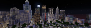
Downtown view from Fort Franklin
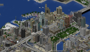
Isometric view

